Observed data: Suspended Solids (SS) for river section 'Pack Horse Bridge, Perry Barr to confluence with River Rea'
Graph of Suspended Solids (SS)
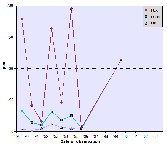
What's on the graph?
The graph shows how suspended solids (ss) data for this river section has changed over time.
Table of Suspended Solids (SS)
| Date of observation | centile10 (ppm) | centile50 (ppm) | centile90 (ppm) | count | max (ppm) | mean (ppm) | min (ppm) |
|---|---|---|---|---|---|---|---|
| 10/1989 | 4.00 | 17.50 | 46.70 | 10 | 179.00 | 33.20 | 4.00 |
| 10/1990 | 5.10 | 8.50 | 33.90 | 12 | 42.00 | 14.33 | 2.00 |
| 10/1991 | 8.00 | 11.00 | 16.00 | 11 | 16.00 | 10.91 | 5.00 |
| 10/1992 | 12.00 | 18.00 | 38.00 | 11 | 164.00 | 31.91 | 12.00 |
| 10/1993 | 9.00 | 15.00 | 27.00 | 11 | 46.00 | 18.27 | 7.00 |
| 10/1994 | 5.10 | 15.50 | 49.50 | 22 | 195.00 | 25.55 | 5.00 |
| 10/1995 | 4.20 | 5.00 | 5.80 | 2 | 6.00 | 5.00 | 4.00 |
| 10/1999 | 114.00 | 114.00 | 114.00 | 1 | 114.00 | 114.00 | 114.00 |
What's in the table?
The table shows how suspended solids (ss) data for this river section has changed over time.
Other options
- Back to WebSMURF river navigation page
- Start again at a new place on the river.